
Lutz J. 2013
Existing Site Conditions
(1) Google Maps
|
(2) Google Maps
|
(3)
Google Maps
|
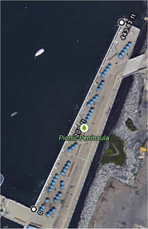
The east side of the future marina is bound by the Picnic Peninsula. It is a pile-supported concrete platform pier that runs parallel to the East River. Under Picnic Peninsula is a stone revetment; it slopes up from the basin bottom to the water edge. Because of this, the revetment absorbs wave energy and does not reflecting it.
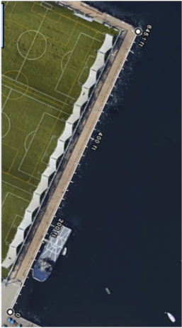
Pier 5, the southern boundary of the site, is a concrete platform pier supported by hundreds of closely-spaced timber piles. The rigidity and density of these piles provides a large amount of wave protection. The end of the pier extending out into the East River, however, sits above deep water levels. Because of this, the outer southern boundary of the marina is not adequately protected from waves.
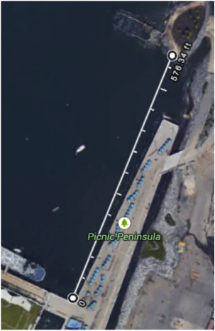
The north side of the basin is bound by Pier 3. Pier 3 constructed similar to Pier 5, and therefore, provides significant wave attenuation to the north. As noted early, remnants of pier 4 still exist within the boundaries of the marina site. It is located about 577 ft North of Pier 5.
Pier 5, the southern boundary of the site, is a concrete platform pier supported by hundreds of closely-spaced timber piles. The rigidity and density of these piles provides a large amount of wave protection. The end of the pier extending out into the East River, however, sits above deep water levels. Because of this, the outer southern boundary of the marina is not adequately protected from waves.
The north side of the basin is bound by Pier 3. Pier 3 constructed similar to Pier 5, and therefore, provides significant wave attenuation to the north. As noted early, remnants of pier 4 still exist within the boundaries of the marina site. It is located about 577 ft North of Pier 5.
Bathymetry

Bathymetric Map of Marina Site
From this bathymetric study between piers 2 and 5, it can be seen that reason why larger breakwaters are not an option. In the circular magnified portion of the picture at the edge of the marina space, water depths reach 25 to 30 feet. In addition, the straight line down the middle of the page represent a subway tunnel. Building a heavy structure on top of the subway could be very hazardous.
River Bottom Conditions

Cross-sections of Brooklyn Bridge Park in Aerial View

Soil Profile A-A'

Soil Profile B-B'
Several different cross-sections of the Brooklyn Bridge Park area were created from borehole drilling data. Cross-sections A-A' and B-B' show the the marina bottom has a top fill layer made up of soft organic material extending 20tf-25ft down. These poor, soft, soil conditions would complicate any foundation built on the river bottom. Furthermore, even 20 ft of fill makes it impossible to dredge due to added costs and even deeper water depth, which require greater wave attenuation measures.
Maximum Wave Height

|
Ferries
The 2002 technical report by Stevens Institute of Technology (SIT) regarding ferry wakes within New York Harbor states, “For the most commonly occurring waves during midday and rush-hours: 2.0 second wave periods will result in waves approximately 20.5 feet long and 3.5 second wave periods will result in waves approximately 62 feet long”. It also suggests that marinas should have attenuation systems capable of protecting a significant portion of the marina from waves over 20“ in height (plus a factor of safety of 1.5) and with periods over 4.25 seconds. |

Google Maps
|
Fetch
The largest fetch measured using the measuring tool in Google Maps was 2.2 miles. The wave height calculated from this fetch then is: Hs=0.25*√Fetch Hs=0.25*√2.2mi Hs=~0.4 ft Windspeed If we use the wind speed of 5mph found for this area, then the wave height would be: Hs = 0.025*U^2 Hs=0.025*5 mph Hs= 1.25 ft Both wave heights generated are less than the 2 foot (24 inches) wave height created by ferry. |
Current Site Specifications
The client for the BBP Marina is currently using the following design conditions:
-95mph unloaded
These are the conditions currently being implemented in the design of the Brooklyn Bridge Park. These are not necessarily the only criteria we used in our design, but are very similar.
- Total Wave height in Marina: 4''
- Wave Period: 3.5 sec
- Tidal Flux: 7'
- Storm Surge 5.5'
- Maximum Design Winds Attenuator can handle
-95mph unloaded
These are the conditions currently being implemented in the design of the Brooklyn Bridge Park. These are not necessarily the only criteria we used in our design, but are very similar.
